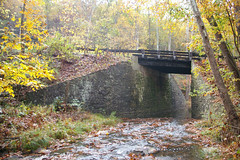
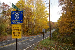
This bridge, seen here from the north, sits on the west side of Sideling Hill, just east of Sideling Hill Creek, at the very western edge of Washington County, Maryland. A couple hundred feet down the road, crossing Sideling Hill Creek, is a concrete arch bridge, built in the 1930s, and the stone abutments of a bridge built in the early 19th century - I'll address them in a future entry. I've written about this bridge before, and will probably do so again at some point.
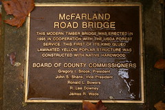
A plaque on the western abutment reads: "This modern timber bridge was erected in 1995 in cooperation with the USDA Forest Service. This first of its kind glued laminated yellow poplar structure was constructed with native hardwood."

This description completely neglects the stone abutments, which are clearly much older.
I've been unable to find any documentation mentioning this bridge - all the statements and photographs have been with regard to the bridge a couple hundred feet down the road. Even the Maryland Historic Trust Historic Sites Survey, usually a repository of information about even the smallest structures, has nothing. I'm reasonably sure that this is a 19th century bridge, but I want to know more! There should be a reference in Bridges: Our Legacy in Stone, the catalogue of the 1965 exhibit at the Washington County Art Museum, but I haven't obtained a copy of it as of this writing.
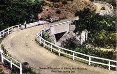
Yesterday I came across this postcard over on the Historical Marker Database. I grabbed the PDF original for a closer look. It appeared that the postcard showed the McFarland Road Bridge!
I noted the old alignment on the five mile map for driving that section of the National Road, working in the twists and turns so clearly evidenced in the photograph. The roads in this area have been straightened considerably, removing many dangerous curves - it seemed quite possible that the curving road in the postcard was the relatively straight one I'd driven several times before.
This is the road as it is today, looking east, as in the postcard. The bridge begins just behind the utility pole. In the full size version of the photograph, the rock outcroppings show evidence of having been cut for the straightening of the road. The path of the road on the postcard could fit the landscape here without too much difficulty.
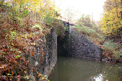
When you look closely at the bridge, you realize it isn't the same structure. The south side, shown here, isn't the same as what is seen in the postcard. The shape isn't right. The road is too high above the water. The far (eastern) abutment is completely different.
I now have a new puzzle - where is (or was) the bridge in the postcard?
No comments:
Post a Comment