In my previous posts, I discussed the jug bridge over the Monocacy River, near Frederick, Maryland, both as it was in the past and as it is today. This post addresses the concrete arch bridge that replaced the stone arch bridge - which has since been replaced by a steel bridge.
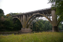
The north side of the bridge, as seen from the edge of the Monocacy River.
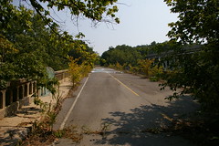
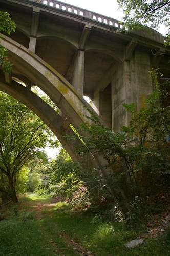
The deck of the bridge, which seems quite servicable, save for the plants growing in the cracks.
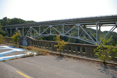
Finally, the newest bridge, as seen from the concrete arch bridge.
9 comments:
The stories of the three bridges here are fascinating, and thank you for sharing what you know.
I have been studying the photos of the abandoned cement bridge. I am surprised to see how well it has held up -- even the striping looks good.
I'm really surprised that they no longer run traffic over it - I can't think of any good reason why. I wonder if it might be some sort of porkbarrel project.
My 4th great-grandfather helped build the Jug Bridge. We visited it, as near we could, and are curious about the toll house, big white house on the now "Doc Bennett Rd.", I believe it is. Was the Jug on the same end or across the river almost in Fredrick?
Do you know what happened to the middle parts of the bridge?
Margaret
Margaret,
I'm not sure about the big white house on Dr. Baxter Rd. If you continue west on that road, past the "No trespassing" signs, you will get to what is left of the jug bridge. The round pad that the jug sat on is still visible, if you look carefully, on the north side of the road. You can read more about it in this entry about the eastern abutment of the jug bridge.
My understanding (though I've never seen it) is that the toll house was on the western side of the river, on the north side of the road.
You are correct about the toll house. The house I was referring to was probably an Inn, possibly owned by one of my family.
My ancestor George Jacobs, from Prussia, helped build the bridge and Leonard Harbaug was his sponsor for obtaining citizenship in this country.
I'm loaded with questions!
Please contact me at: curjax@accesstoledo.com Thanks!
Both the concrete and steel spans were open and in use for years together, the concrete span carrying 2 lanes of west-bound traffic, the steel span (to the south) carrying two lanes of east-bound traffic.
The concrete-arch bridge was closed sometime around 1986-89 (I believe - shortly before building of the Spring Ridge community, east of the Monocacy River, was started) because a west-bound tour bus hit the abutment/guard railing on the east end on a rainy Sunday afternoon, and caused some structural damage. Originally, the closure was temporary until a full assessment and repairs could be made, but someone apparently decided there wasn't enough traffic to warrant the cost of repairs. I was living very close by at the time and heard about the accident within a couple hours of arriving home from road trip. So no porkbarrel - just a safety issue.
Thank you for posting some of the history and all the photos. These are the best photos of the original bridge that I have ever seen!
Kathy
Kathy,
Thank you for that clarification. While it may be easy to get out in the field to take photographs, that sort of history can be much more challenging.
The jug originally sat on east side. The remanents of the stone bridge are still on both sides. You can get to east side from liganore rd. The place the jug sat is still there. still an amazing piece of construction. I used to play around those growing up in late seventies and eighties. The stone bridge was blown up. You used to be able to sse the stone in the rive on a clear day when the river was low. I still rmemeber the CMS crosess and the big tire from the bus.
Bill (formerly of pinecliffe dr on east side)
Does anyone know if the two bridges over the Monacacy River were used in tandem at one time. If you look at the striping on the old, abandoned bridge, one shoulder stripe is white while the other shoulder stripe is yellow, suggesting that the abandoned bridge handled westbound traffic.
Post a Comment