Friday, September 28, 2007

Peacock Road

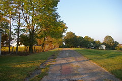
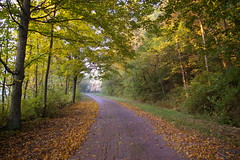
Peacock Road is a section of the Historic National Road between Old Washington and Cambridge, Ohio. It has been bypassed by faster routes, so it has been changed less over time. It retains the early 20th century brick paving, and it makes for a beautiful drive.

Peacock Road, between Old Washington and Cambridge, Ohio

Peacock Road, between Old Washington and Cambridge, Ohio

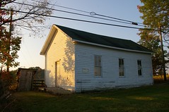
One room schoolhouse, Peacock Road, between Old Washington and Cambridge, Ohio

Wednesday, September 26, 2007

Stone bridges on the National Road in Maryland

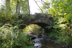
I was somewhat surprised when I learned about a stone bridge, just west of Grantsville, Maryland - all I knew about in Grantsville was Casslemans River bridge. This other bridge is a bit worse for the wear, with its single arch partially collapsed, but is still quite presentable.

Stone bridge, just west of Grantsville, Maryland

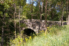
A couple miles down the road, a stone National Road bridge spans Puzzley Run. This bridge is on private property, but can be viewed without trespassing.

Puzzley Run Bridge, west of Grantsville, Maryland

These finds led me to make a map of all the stone National Road bridges in Maryland:


View Larger Map

Tuesday, September 18, 2007

All those maps

I've just added links to all of my National Road maps. Note that the ones for Pennsylvania and westward are based purely on sattelite photographs and maps - I have not yet had the opportunity to field check this data.

Before too long, I'm going to draw a list of maps, with driving directions, on how a reasonable person might drive the National Road.

Replacement milestones

I was going to post about how to identify old alignments today, but I've been having trouble with the maps I've embedded from Google Maps actually working, so instead, I'll deal with the issue of replacement milestones.

Milestones 1-40 are solid, heavy affairs, not the sort of thing that is easily damaged or moved - thus, these stones have mostly remained in their original locations, undamaged - even if through weathering they have become unreadable. West of milestone 40, however, the stones are smaller, cut of softer sandstone, which lead to easier carving, but also lead to being damaged more easily. The stones were placed along the edge of the road, which, in the automobile age, has lead to many suffering damage in automobile accidents.
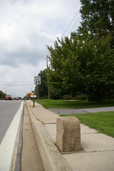
52 M to B
52 M to B is the most easternly replacement stone.
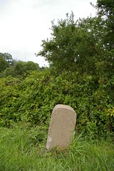
56 M to B
56 M to B is identical in style to milestone 52.

Imposter / replacement 58 M to B
58 is a bit less stout than the two preceding it.
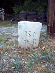
75 M to B
I just don't know what to say about milestone 75. Someday I'll talk to the inhabitants of the house and ask them if they know anything.
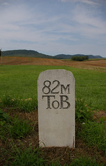
82 M to B
The text on 82 M to B appears to have been sandblasted.

Milestone 96 M to B
This rather nice replacement is in Hancock, Maryland.

97 M to B
97, along with its twin, 96, appear to be relatively recent replacements.
Monday, September 17, 2007

Illinois and Indiana

I was fortunate enough to stumble across Jim Grey's documentation of his journeys on the National Road in Indiana, from Indianapolis to the Illinois border and Illinois.

He documents the journey with photographs and maps, illustrating historic alignments and interesting things he saw along the way. I hope to take a similar approach to the eastern chunk of the Road.

Saturday, September 15, 2007

National Road in Maryland - Milestones 51-75


View Larger Map

The blue line indicates the original alignment of the road.

Blue flags indicate milestones that I've been able to locate and photograph - click on a flag for a photograph of the milestone. Light blue flags indicate replacement milestones. Red flags indicate milestones that I have not been able to locate or photograph.

I'm not sure why all the stones in Hagerstown are missing. I need to look harder in that area. Perhaps some research in the Western Maryland Room of the Hagerstown branch of the Washington County Library will provide an answer.

National Road in Maryland - Milestones 26-50


View Larger Map

The blue line indicates the original alignment of the road.

Blue flags indicate milestones that I've been able to locate and photograph - click on a flag for a photograph of the milestone. Red flags indicate milestones that I have not been able to locate or photograph.

A Traveler's Guide to the Historic National Road in Ohio

Yesterday, I recieved a copy of A Traveler's Guide to the Historic National Road in Ohio. It's a quite impressive production - 45 pages, glossy, full color, and is available free for the asking from the Ohio Historical Society, by sending an email to info@ohiohistory.org or by calling them, or can be picked up in person at the visitor centers at the ends of the state on I-70.

In addition to a more extensive backstory, the pamphlet includes full driving directions for following the extant portions of the Road in Ohio - the directions which are included in much briefer format at ohionationalroad.org.It identifies, from what I can tell, every extant stone bridge on the Road in Ohio.

Highly recommended.

Missing milestone sighting!

Thanks to the illustrious rmcgervy, a fugitive Pennsylvania milestone has been found. The (cast iron) stone indicates 78 miles to Wheeling and 53 miles to Cumberland, and is located at Friendship Hill National Historic Site, in Pennsylvania.

If you know of any other National Road milestones in locations other than on the road proper, I'd love to hear about them.

Wednesday, September 12, 2007

National Road in Maryland - Milestones 1-25


View Larger Map

The blue line indicates the original alignment of the road.

Blue flags indicate milestones that I've been able to locate and photograph - click on a flag for a photograph of the milestone. Red flags indicate milestones that I have not been able to locate or photograph.

Tuesday, September 11, 2007

Introduction

This blog is my attempt to describe and share my journeys on the National Pike, as it winds its way from Baltimore to Cumberland, Maryland, as well as the National Road, from Cumberland, Maryland, to Vandalia, Illinois. I plan to include plenty of photographs, maps to describe the journey.