Thursday, February 28, 2008

The Old Bank Road Toll House, west of Hancock, Maryland

Bank Road Toll House, west of Hancock, Maryland
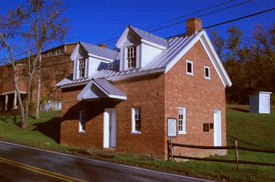
I've always been curious about the row of joists on the front of the Bank Road toll House, on the National Road, just west of Hancock, Maryland, at the western edge of Washington County. There was just something about them that felt wrong. Additionally, the tollhouse seemed too close to the road.

Bank Road Toll House, west of Hancock, Maryland
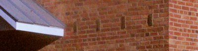
The joists can be seen a bit better in this detail, taken from the above photograph.

Toll house near Hancock
Courtesy of the Enoch Pratt Free Library, Central Library / State Library Resource Center, Baltimore, Maryland

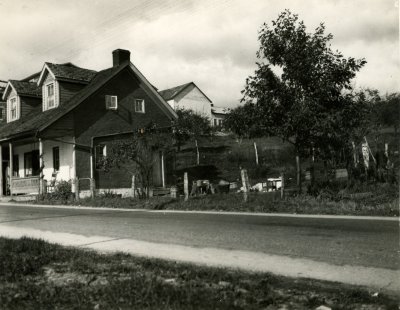
I found this photograph, taken by the Maryland State Department of Forestry, in November of 1936, which helps explain what happened. The road was widened, and rather than move the building, the porch was eliminated. With the porch present, the dimensions of the toll house seem more appropriate with one would expect of a structure from this region and time.

Also note that the toll house originally had gutters. It seems that the present lack of them may eventually cause structural issues for the building. In addition, they seem to tie together the visual appeal of the tollhouse.

I'm torn, as a historic preservationist, whether to advocate having the building moved and returned to its original state, or to advocate leaving it in its original location. I'd love to see the road moved, but that is almost impossible. Perhaps a historical marker, from a vantage point similar to the one above, showing it as it was, would help illustrate the situation.

Old Photographs from the Maryland Department, Enoch Pratt Free Library

New Carroll Creek Bridge, East Patrick Street
New Carroll Creek Bridge, East Patrick Street, Frederick, Maryland, 1926. Photograph by the Maryland State Roads Commission. Courtesy of the Enoch Pratt Free Library, Central Library / State Library Resource Center, Baltimore, Maryland

I've just uploaded more than 100 black and white photographs, virtually all of them taken between 1900 and 1940, relating in some way or another to the National Road in Maryland. The photographs are from the Maryland Department of the Enoch Pratt Free Library, in Baltimore, Maryland. Many of them were taken by the State Highway Administration, documenting construction and realignment of roads and bridges. Others were taken by the Historic American Buildings Survey, documenting historic structures on or near the National Road. Still others were taken by the Maryland National Guard, providing aerial views of various Maryland towns along the National Road. Finally, some were taken by private individuals, but are old enough that they have passed into the public domain.

I will be writing more about the individual photographs in coming weeks, as well as providing maps and detail descriptions. Expect the descriptions on the individual photograph pages and other metadata to increase.

Wednesday, February 27, 2008

The National Road, Most Historic Thoroughfare in the United States, and Strategic Eastern Link in the National Old Trails Ocean-to-Ocean Highway

I recently had the fortune to find a copy of Robert Bruce's classic 1916 title on the National Road with the binding in rather sad condition. Bruce originally wrote the book as a set of nine articles for the AAA. They were later published together by the Brooklyn Eagle Press, in 1916. I've taken the liberty of scanning it, in its entirety.

The book includes history, photographs, driving directions, and an extensive collection of maps showing the route of the National Road and adjoining routes.

Wednesday, February 20, 2008

Middletown, Maryland

Middletown
The National Road forms the Main Street in Middletown, a small town, west of Frederick, Maryland. It is seen here from the east edge of town, looking west.

Middletown Memorial Town Hall
The Middletown Memorial and Town Hall is a wonderful historic building. Someday, some good person will remove the utility lines so that a better photograph might be created. It appears to be unused at the present.

Beautiful brick building (detail)
It is unclear what purpose this brick building, built in 1888, originally served. Now it appears to be a private residence.

Two curious buildings
These buildings make a curious pair. One is (or was) a barber shop, but the original use of the other is not obvious.

Middletown
As one travels west, the buildings become primarily residential.

Two stone arches for the price of one

Two alignments
Just east of Mt. Airy, Maryland, is Parrsville. This rarely visited section of the National Road was cut off by the construction of Interstate 70. Both of the roads shown in this picture are actually sections of the National Road. The one that looks almost like a driveway was for an at-grade crossing of the Baltimore and Ohio railroad, which was replaced by a bridge, the road on the left, in the 1920s.

Grade crossing elimination
This photograph, taken in 1930 by the Maryland State Roads Commission, was taken from a similar angle to the one above. It shows the construction of the new alignment, on the left. Courtesy of the Enoch Pratt Free Library, Central Library / State Library Resource Center, Baltimore, Maryland.

Old alignment
From the train tracks, looking west, the remains of the older alignment and a church are visible. It also seems to have become a dumping ground for trash.

Old bridge
From the same spot, looking to the northeast, the bridge that used to carry the National Road over the B&O can be seen. The guardrail on the right is for the westbound lanes of Interstate 70.

Stone culvert
I didn't think much of this old alignment until I looked over and saw this stone culvert. The construction of it is different from what I am used to seeing - the stones are longer, and the construction is more precise. To the right of this stone arch was a larger one, 20 feet wide, that, for some time, carried the B&O over the National Road.

Stone culvert
The other end of the culvert illustrates the nature of the construction a bit better. According to B&O RR Photo Tours, this culvert carried an old route of the B&O during the 1830s, before the route was changed. It's amazing that this stone structure has (mostly) held up for 170+ years with no maintenance whatsoever. The B&O really built things to last.

Stone culvert
From the point where I first photographed the B&O culvert, I noticed something else, on the old National Road alignment - another stone culvert! This photograph was taken from virtually the same position as the vertical one of the B&O culvert. It has held up reasonably well, though it wasn't always so covered with debris.

Stone culvert
The south side of the culvert hasn't fared as well.

Other National Road blogs

I somehow missed this update from Jim Grey, Indiana and Illinois National Road Revisited. I love that the state had the foresight(?) to have a sign ordering people to not remove bricks from the old alignment.

You might also be interested in Patricia McDaniel's National Road travel journal.

Friday, February 15, 2008

Casselman River Bridge postcard

Castleman River Bridge. Built 1813
So, someone occasionally spends a bit too much time on eBay. I just got this nice postcard, so I made a high resolution scan and thought I'd share it. It shows the Casselman River Bridge, a National Historic Landmark on the National Road, east of Grantsville, Maryland.

dixie tavern
This sign, on the trees to the left of the bridge, is for the Dixie Tavern.

noparking
This sign is just before you cross the narrowest part of the bridge. It reads "No parking opposite white line."

Hollow Road Creek bridge

Stone arch bridge over Hollow Road Creek (location)
The casual driver on the National Road in Frederick County, Maryland probably wouldn't notice the bridge here, over Hollow Road Creek. The landscape is relatively uninteresting - a golf course on the south side of the road, some newer homes on the north. This view, looking eastbound, shows the visual clue that led me to suspect there might be something interesting here - the abnormally thick wall on the right side of the bridge.

Stone arch bridge over Hollow Road Creek
I put on my hiking boots and got a bit closer. My suspicion was confirmed - a stone arch bridge!

Stone arch bridge over Hollow Road Creek
This is the south side of the bridge, as seen from the middle of Hollow Road Creek.

Stone arch bridge over Hollow Road Creek
The construction of the bridge seems a bit atypical - the walls of the bridge ususally either go straight or curve, but not both.

Stone arch bridge over Hollow Road Creek
The bridge was widened, in 1975, it seems.

Stone arch bridge over Hollow Road Creek
Underneath the bridge, half of the stucture remains stone.

Eastern Jug Bridge abutment

Remains of the Jug Bridge, Monocacy River, Frederick, Maryland

I've written previously about the famous Jug Bridge over the Monocacy River, both as it was in the past and as it is today. I've also written about the concrete arch bridge that was built to replace it in 1944.

I've never, though, written about the eastern abutment of the Jug Bridge, nor have I been able to locate any non-historical photographs of it. The above photograph was all that I'd been able to get documenting this bit of history, and I wasn't even sure that it showed anything.

Old National Road alignment
The road is still in relatively good shape, given that it hasn't been maintained since 1944. This view is looking back toward the end of the public road.

Old National Road alignment
It gradually becomes more overgrown.

Eastern abutment of the Jug Bridge
This is the end of the road, the eastern abutment of the bridge. The road made a sharp right to cross the bridge just beyond the left edge of the picture. The small white building seen to the right was the toll house for the bridge.

Eastern abutment of the Jug Bridge
The utility line (click on the picture for a larger version) marks the left (south) side of the old bridge abutment.

Eastern abutment of the Jug Bridge
This wall formed the north side of the bridge.

Eastern abutment of the Jug Bridge
This photograph was taken from the spot shown in the preceding one. It helps illustrate how the road curved before crossing the river.

Eastern abutment of the Jug Bridge
This photograph, taken from approximately the same spot as the preceding one, shows the former location of the "jug" for which the bridge was known, and which now sits in a park in Frederick. It sat on the round, semicircular stone pad, about a third of the way up the image, now covered by moss.

Eastern abutment of the Jug Bridge
This is the north wall of this abutment. Note the concrete arch bridge that replaced the Jug Bridge in the background, as well as the replacement's replacement.

Eastern abutment of the Jug Bridge
This is what remains of the south wall of this abutment.

Monday, February 11, 2008

More stone bridges and culverts


View Larger Map

I've updated my map of the stone bridges and culverts on the National Road, adding five new structures as well as replacing a few photographs. I believe that there are still more to be found, and with time, I will photograph them all. Click on any blue flag for a picture of the bridge or culvert in question.

Another stone arch culvert

Stone bridge
This culvert is on the National Road, in Frederick County, Maryland, about 1.6 miles east of New Market. This is its south wall.

Stone bridge (location)
When driving down the road, you'd miss it if you didn't know it was there. Interstate 70 is visible in the distance. This view is from the west, looking east.

Stone bridge (detail)
At some point, some rather clumsy mortar repair was done.

Stone bridge
The north wall of the culvert has deteriorated and had dirt filled in around it.

Another hidden stone arch culvert

Concrete bridge over a stone arch
As I mention in my previous entry, I've stopped on the old National Road alignment just east of New Market a couple times to take photographs.

Concrete bridge over a stone arch
The structure seemed to be nothing more than a simple concrete box culvert, probably built in the 1920s or 1930s.

Concrete bridge over a stone arch
However, on closer inspection, a stone arch is revealed. This is the south face of the culvert. The construction of the north face is similar.

A spring house, hidden in the woods

Spring house, as seen from the concrete bridge

I've stopped a couple times on the old alignment of the National Road, just to the east of New Market, Maryland. The road was moved to go around an exit for Interstate 70, but the old road bed remains open to vehicular travel.

There's a 1920s-30s concrete bridge, but other than that, there isn't much to see. At least that's what I thought.

When I stopped on this bit of road on Friday, I noticed the stone structure shown above, just a bit to the north of the bridge. I was surprised, as I would think I would have seen something like this before.

Stone spring house
I approached the building. It appears to have been constructed during the first half of the 19th century. This view is taken from the southeast, looking northwest. A small window is visible on the east wall.

Stone spring house
A doorway on the west wall allows access. No door is present.

Stone spring house (detail)
The masonry is in very good condition, however the wood does show some decay.

Interior of spring house
Inside, there is a channel, which appears to have been created to allow water from a spring or nearby stream to flow and cool the foodstuffs stored inside.

Protecting the spring?
Outside, parallel with the front of the structure, a few feet to the south, is this construction. It appears to be covering a spring, though no water was present when the photograph was taken. Perhaps the water flowed out of this spring and into the structure.

Tuesday, February 5, 2008

Some reading

I'm busy writing captions for all the photographs I scanned last week from the Maryland Department at the Enoch Pratt Free Library. Though they were all either created by government agencies, and therefore, free to use, or are in the public domain due to age, I'm still waiting to get the paperwork regarding the rights to use the imagery. I've already started going through the images again, at a more relaxed pace, hoping to find some new bits that I missed. I've learned a fair amount by looking at the photographs, and I think that with those insights, I may be able to get more out of another browse through the photo collection. On the other hand, I may just spend the time scanning the photographs from the State Highway Administration annual reports, which contain more useful information, I think.

I've been browsing Google Books, and a couple classic National Road titles have come to my attention: Thomas Brownfield Searight's The Old Pike: A History of the National Road; The Old National Road: A Chapter of American Expansion; and The Cumberland Road (from the Highways of America series) both by Archer Butler Hulbert. Multiple copies were listed for these titles - I have linked to the ones that appear to have the best / most complete pictures. This said, I may eventually provide high resolution scans of the plates. A few other titles, not quite classics, but interesting reads nonetheless include The National Road in Indiana by Lee Burns, A Political and Constitutional Study of the Cumberland Road by Jeremiah Simeon Young, and one Executive Communication to the General Assembly of Maryland, at December Session, 1818, on the Subject of Turnpike Roads.

Monday, February 4, 2008

A different sort of road junkie

I recently discovered B&O RR Photo Tours, a wondeful website documenting the remains of the historic Baltimore and Ohio Railroad in the Baltmore area. It's especially interesting because of the number of stone bridges and culverts that remain in service, including two National Historic Landmarks - the Carrollton Viaduct and the Thomas Viaduct. Like the National Road, the B&O used milestones. Surprisingly, they are much better condition than their counterparts on the National Road, even though they are but 30 years younger.

The website also provided some insight into a bit of confusion I've had about an old alignment east of Mt. Airy. It seems that there used to be an at-grade crossing, which was later changed to a bridge - which explains the two old alignments. I've obtained a photograph of the creation of the new alignment, and will be posting it shortly.