Wednesday, January 30, 2008

The National Road in Baltimore

I've focused a bit too much on the rural aspects of the National Road while ignoring the parts of it in my own back yard.

Row Houses, National Road, Baltimore
The National Road is split into two one way streets in downtown Baltimore - Lombard Street heading west and Pratt Street going east. The streets are lined with that icon of Baltimore architecture, the rowhouse. Here they are seen, looking east, with the skyline rising in the background.

Row Houses, National Road, Baltimore
Formstone helped protect the walls of some of the houses that were made out of such cheap brick that they would weep moisture if not regularly painted.

Row Houses, National Road, Baltimore
This view, looking west toward Union Square, suggests that some prosperity may be returning to the neighborhood.

H. L. Mencken House
On the opposite side of Union Square, one block north of Lombard Street, lies 1524 Hollins Street, former residence of author and journalist H. L. Mencken. The house, a National Historic Landmark, is not currently open to the pubic.

Old National Road alignment, Baltimore
As we head west, the two halves of the road meet up and become one - Frederick Avenue. This old section of the road is just to the east of the Gwynns Falls. The route of the road was changed when a new bridge was built over the Gwynns Falls in the 1930s.

Old stone bridge support, Frederick Road at Gwynns Falls
From below, one can see the remains of the old bridge.

Row Houses, National Road, Baltimore
This view, looking east, shows the current route of the road. The old bridge was to the right.

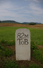
Milestone 3 M to B
Milestone 3 is the first one extant in the city.

Loudon Park National Cemetery
Just across the road is Loudon Park National Cemetery. Immediately to its west is Loudon Park Cemetery, whose tens of thousands of graves include H. L. Mencken and Ottmar Mergenthaler, inventor of Linotype.

Monument to the soldiers in World War I from Irvington
This marker, on the north side of the road, commemorates those from Irvington who served in World War I.

As we head west, we pass through the Irvington neighborhood, and the accompanying marker, installed by American's Byways.

Milestone 4 M to B (location)
One can almost spot milestone 4, hidden in the stone wall and brush on the north side of the road.

Former service station, National Road, Baltimore
Kim's Carryout and Grocery, a former service station, is on the north side of Frederick Avenue, just east of South Rock Glen Road.

Baltimore National Cemetery
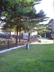
Baltimore National Cemetery sits on the south side of the National Road.
Milestone 5 M to B
In front of Baltimore National Cemetery sits milestone 5 M to B, the only original milestone on the south side of the road. I strongly suspect that it may have been moved with the widening of the road.

This brings us to the western border of the city of Baltimore.

Tuesday, January 29, 2008

Historical Markers, News, and Photographs

I haven't posted much in the past few days. This is due to two factors.

I've been playing around some over at the Historical Marker Database, which is interesting - you can even see a map of the markers I've added or contributed to - though I think I like the historic sites more than the markers. I am going to try to figure out how to map the historical markers within a mile or so of the National Road.

I discovered that the photograph collectionMaryland Department of the Enoch Pratt Free Library includes hundreds of photographs from the State Highway Administration. These images document the replacement of bridges, the straightening of roads to reduce dangerous curves, as well as images that simply show construction techniques. I spent the day today (I'm taking a little vacation time) going through the tens of thousands of photographs, to make sure I found everything that might be of interest. In addition to the Highway Administration, I found good photographs from the Historic American Buildings Survey, the Works Progress Administration, and some photographs from non-governmental sources which should be in the public domain. Thursday, I'll spend the day scanning them. After that, I'll start making them available as soon as I can.

Friday, January 25, 2008

The Antietam and its Bridges

Turnpike Bridge at Funkstown

I had the pleasure recently to check out, from the Washington County Free Library a copy of Helen Ashe Hays' 1910 book, The Antietam and its Bridges, which contains 17 excellent photogravures by John C. Artz of stone bridges along the Antietam Creek as it meanders its way to the Potomac.

This copy had been quite well loved, and the binding was so well worn that I realized I'd be able to scan it without damaging the book. Given the publication date, the work is in the public domain, so I offer you the aforementioned photogravures. Unfortunately, one of the plates was missing, but that does not significantly impact the work as a whole.

Only one of the bridges is actually on the National Road - the Turnpike Bridge, at Funkstown, shown above, before the 1930s widening, but several are within a mile of the Road, and would make an excellent diversion for the traveller following the route.

Funkstown Bridge
Funkstown Bridge Number 2 just a short distance downstream from the Funkstown Turnpike bridge.

Bridge at Rose's Mill
The bridge at Rose's Mill

Claggett's Mill
Claggett's Mill

Bridge at Claggett's Mill
The bridge at Claggett's Mill

Tuesday, January 22, 2008

The photographic potential of a cold day

Milestone 3 M to B
Milestone 3 M to B

I took advantage of having Monday off and did a little photography. I didn't stray too far - it was cold - but I did get some nice photographs of the National Road, in the Catonsville / Ellicott City area.

I've also been working to document the sites National Road milestones to make it easier for the tourist to locate them.

Milestone 4 M to B (location)
Milestone 4 M to B (hiding in the far right of the picture).

Milestone 7 M to B
A better photograph of milestone 7 M to B and the accompanying historical marker.

Historic National Road, Ellicott City, Maryland
An old alignment, between Catonsville and Ellicott City.

National Road, Ellicott City, Maryland
Looking toward Ellicott City. This is the location of the stone culvert below.

Stone arch culvert, Ellicott City, Maryland

Friday, January 18, 2008

Another perspective on the National Road, with more history and less rambling!

I came across Ryan's History and Education Site Blog this morning. He presents the history of his area, West Virginia and western Pennsylvania, utilizing historic photographs.

Ryan has a few entries that might be interesting: Traveling the National Road - Taverns and Wagon Stands; The Old National Road and Early Politics; and The S Bridge.

Fitting the Data to the Theory - the McFarland Road Bridge

McFarland Road Bridge, Old National Road, west side of Sideling Hill
This bridge, seen here from the north, sits on the west side of Sideling Hill, just east of Sideling Hill Creek, at the very western edge of Washington County, Maryland. A couple hundred feet down the road, crossing Sideling Hill Creek, is a concrete arch bridge, built in the 1930s, and the stone abutments of a bridge built in the early 19th century - I'll address them in a future entry. I've written about this bridge before, and will probably do so again at some point.

McFarland Road Bridge, Old National Road, west side of Sideling Hill
A plaque on the western abutment reads: "This modern timber bridge was erected in 1995 in cooperation with the USDA Forest Service. This first of its kind glued laminated yellow poplar structure was constructed with native hardwood."

McFarland Road Bridge, Old National Road, west side of Sideling Hill
This description completely neglects the stone abutments, which are clearly much older.

I've been unable to find any documentation mentioning this bridge - all the statements and photographs have been with regard to the bridge a couple hundred feet down the road. Even the Maryland Historic Trust Historic Sites Survey, usually a repository of information about even the smallest structures, has nothing. I'm reasonably sure that this is a 19th century bridge, but I want to know more! There should be a reference in Bridges: Our Legacy in Stone, the catalogue of the 1965 exhibit at the Washington County Art Museum, but I haven't obtained a copy of it as of this writing.

National Pike, at the foot of Sideling Hill Mountain
Yesterday I came across this postcard over on the Historical Marker Database. I grabbed the PDF original for a closer look. It appeared that the postcard showed the McFarland Road Bridge!

I noted the old alignment on the five mile map for driving that section of the National Road, working in the twists and turns so clearly evidenced in the photograph. The roads in this area have been straightened considerably, removing many dangerous curves - it seemed quite possible that the curving road in the postcard was the relatively straight one I'd driven several times before.

Welcome to Washington County, Maryland
This is the road as it is today, looking east, as in the postcard. The bridge begins just behind the utility pole. In the full size version of the photograph, the rock outcroppings show evidence of having been cut for the straightening of the road. The path of the road on the postcard could fit the landscape here without too much difficulty.

McFarland Road Bridge, Old National Road, west side of Sideling Hill
When you look closely at the bridge, you realize it isn't the same structure. The south side, shown here, isn't the same as what is seen in the postcard. The shape isn't right. The road is too high above the water. The far (eastern) abutment is completely different.
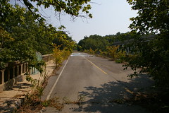
I now have a new puzzle - where is (or was) the bridge in the postcard?

Wednesday, January 16, 2008

A stone culvert, hidden in plain view

I was using local.live.com, tracing the National Road in Catonsville, Maryland, looking for old alignments and other things that might catch my eye. I was using the high resolution aerial photographs, following the course of the National Road along the Patapsco River, when I came across a curious structure.
It looked like a stone culvert, carrying some stream under the National Road, into the Patapsco River. This seemed impossible - surely I would have noticed it on the many times that I've driven by - right?

If you are on the National Road, heading west, following the Patapsco River, you'll get to a gas station. Park in the parking lot of the gas station. You won't be able to see anything obvious from the road. Just after the gas station is a concrete culvert:
Twin stone arch culvert, just east of Ellicott City, Maryland

The culvert is taller than the photograph suggests - the water level is usually very low - such that I had no trouble walking (albeit rather bent over) down the culvert to the other side. It's also possible to just cross the road, but it's a five or six foot drop, and there's a fair amount of brush.

About halfway through the culvert, it goes from concrete to stone:
Twin stone arch culvert, just east of Ellicott City, Maryland

When you emerge on the other side and step back, a double arch stone culvert is revealed:
Stone culvert, Ellicott City, Maryland

When the road was widened, the culvert was widened to accomodate the road. This is rather common for stone culverts on the National Road in Maryland. One can also find several bridges in Washington County, Maryland that have been treated similarly.

Casselman River Bridge

Casselman River Bridge, Grantsville, Maryland
The Casselman River Bridge, east of Grantsville, Maryland, carried the National Road over the Casselman River, beginning in 1815. At the time it was built, it was the largest bridge of its type.

Casselman River Bridge, early 20th century
The bridge had fallen into considerable decay by the early 20th century.

Casselman River Bridge
It was restored in 1911 to carry automobile traffic and remained in operation until 1933, when a steel truss bridge on a newer alignment of US Route 40 replaced it.

Casselman River Bridge, Grantsville, Maryland
The bridge was designated a National Historic Landmark in 1963. It is operated by the state of Maryland as a state park.

Casselman River Bridge
This illustration, from the Historic American Buildings Survey, shows the location of the bridge relative to the new alignment of Route 40.

The Wilson Bridge, at sunrise

Wilson Bridge over Conococheague Creek
One last photo of the Wilson Bridge.

Tuesday, January 15, 2008

The Wilson Bridge

Wilson Bridge, Conococheague Creek, near Hagerstown, Maryland
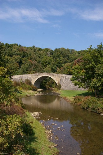
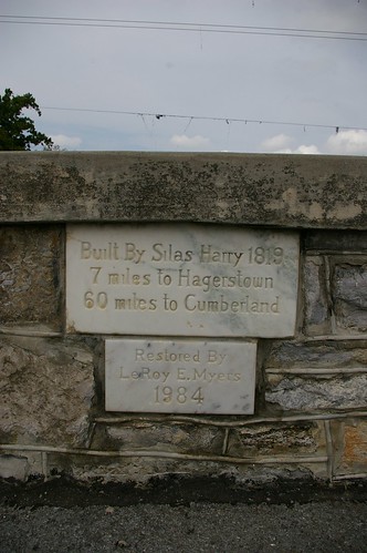
The Wilson Bridge carried the National Road over the Conocoheague Creek, west of Hagerstown, Maryland. The five arch stone bridge, spanning 215 feet, was built by Silas Harry in 1819, at a cost of $9,100. This photo, from the Historic American Buildings Survey, shows the bridge in use, in the 1930s.

085009pv
It was superceded in 1937 by this concrete arch bridge.

The stone arch bridge remained in use until June, 1972, when it was damaged by Hurricane Agnes.

Wilson Bridge, Conococheague Creek, near Hagerstown, Maryland Wilson Bridge, Conococheague Creek, near Hagerstown, Maryland
A flood damaged one arch of the bridge in 1982. It was scheduled for demolition, due to safety concerns and the high cost of restoration - estimated to be $300,000-$400,000. However, due to public concern, the bridge was restored and made into a public park.

Wilson Bridge, Conococheague Creek, near Hagerstown, Maryland
It's interesting to note the rubble filled interior construction of the bridge.

Wilson's Bridge
Silas Harry completed the restoration work in 1984.

Wilson's Bridge
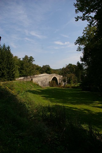
The bridge now stands in excellent condition, ready to last another 150 years.

Former National Road leading up to Wilson's Bridge
The area leading up to the bridge, from the east, includes several picnic tables and a historical marker.

Old wood and cable guard rails, just east of Wilson Bridge
The remains of some old guard rails remain, hinting at a time when the road didn't dead-end into a parking lot.

Aside from the first image, black and white images are by William Edmund Barrett, for the Historic American Buildings Survey.

For additional photographs, see my set of images of the bridge over on Flickr.

Monday, January 14, 2008

Driving Route Maps Updated!


View Larger Map

Over the course of the past week, I've gone through all of the small (5 mile segment) driving maps of the National Road in Maryland and completely updated them. Driving routes are correct for the entirety of the state. Virtually all old alignments have been noted, to the extent that the aerial photographs allow me to see. The driving route is shown in blue, the eastbound driving route, if different, in light blue, drivable old alignments, in green, and undrivable old alignments, in red. Points of interest will be added in coming weeks.

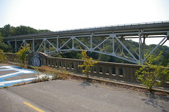
Concrete arch bridge over the Monocacy River

Old bridge, Monocacy River, Frederick, Maryland

In my previous posts, I discussed the jug bridge over the Monocacy River, near Frederick, Maryland, both as it was in the past and as it is today. This post addresses the concrete arch bridge that replaced the stone arch bridge - which has since been replaced by a steel bridge.

Old bridge, Monocacy River, Frederick, Maryland
The north side of the bridge, as seen from the edge of the Monocacy River.

Old Route 40 bridge over the Monocacy River, Frederick
The deck of the bridge, which seems quite servicable, save for the plants growing in the cracks.

Old and new bridge for Route 40, over the Monocacy River, Frederick
Finally, the newest bridge, as seen from the concrete arch bridge.